At Woodsboro I grabbed a couple more energy bars and a bottle of orange
juice. Not much of a breakfast, but I didn't feel like having any more.
The climb out of Woodsboro on Coppermine Road was a nasty 15% grade in
surprisingly heavy traffic. Fortunately only one car passed me on the
climb. Later I found the source of the traffic: a church. After that
things got a little better.
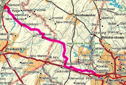
Coppermine Road was all up and down. Grinding climbs followed by
screaming descents. After I crossed MD75 the traffic went away and the
hills got less steep and more rolling.
Coppermine Road: The Good Part
As I came down Clemonsville Road into
Unionville I passed a church. A man who was apparently the minister was
outside (having just arrived) and he yelled something to me about
church. I didn't understand him so I nodded as I cruised by. He was
probably inviting me in.
MD26 is a busy road with high speed traffic and a huge, high-quality
shoulder. I started climbing right away and reached the highest point
of the day at the Carroll County line. I stopped briefly for an iced
tea at Taylorsville and then turned south at Winfield. Hoods Mill Road
and Morgan Road were all downhill until I reached the Patapsco River.
Then it was uphill to Old Frederick Road. The Morgan/Morgan Station
Road
crossing is by far the most pleasant place to cross between Howard and
Carroll Counties. All the other roads either involve steep climbs or
heavy traffic. My route had almost no traffic.
The rest of the ride was almost all downhill. Even so, I started
feeling like I should have eaten more. With about one mile to go I
passed a fruit stand and had to stop and buy a pint of strawberries.
They
were all gone before I got home.
What did I learn from this ride? I learned that you can't be in a
hurry when you're hauling touring gear. I learned that there are no
easy hills, just hard hills, harder hills, and brutally hard hills. I
learned that you can go really fast downhill when you're carrying 40
pounds more than you're used to. And most importantly, I learned that
you should leave all your stuff in plastic bags when you stay in a
smoking room.