Dry Run 2: Day 1

8 May 2004
Glenelg, MD to Harpers Ferry, WV
60.9 miles, 5h07m, 11.9 mph
Elapsed Time: 7h28m, Max speed: 40.7mph
Total Climbing: 4328ft, Max elevation: 860ft


Copyright 2002 DeLorme. Topo USA. Data copyright of content owner.


JT and I finally got together to try a fully-loaded trial run in early May. Our destination was Harpers Ferry, West Virginia, where a co-worker (we'll call him "Don") would be camping for the weekend. We made plans to meet and I made reservations at the campground. We talked about it for two days. Then at the last possible moment I found out that Don would be there next week, while we would be riding there this week. A sitcom-like comic situation was barely averted.

I loaded up my bike with everything I thought I'd need for a two day trip. It seems that the difference between a two day trip and a 30 day trip is really only a few jerseys and a couple of pairs of bike shorts. Most of the stuff you need no matter how long or short the trip.

JT loaded his new touring bike up with lots of extra stuff to better simulate actual touring conditions. It looked like he had two trash cans bolted to the back of his bike. He would later experience some stability problems because his center of gravity was too high.

Anyway, my wife Linda drove us to Glenelg in nearby Howard County so that our ride would be no more than 60 miles. We fussed around with our gear for about a half hour and finally got started at about 10am. Amazingly, we rode about 7 miles before we had to stop to adjust anything.

The weather was good. It was a little cool but not cool enough to wear a jacket. It was very windy but the wind was coming from an unusual direction--the southeast--which would help us more than hurt us. With any luck the wind would return to its traditional westerly direction on Sunday to push us home.

Our route started out on the lightly traveled back roads of Howard County. We encountered our first adversity when we attempted to cross into Montgomery County on Hipsley Mill Road. They let us get to within a mile of the construction before we saw a detour sign. By then we decided we would try to get through anyway--usually bikes can get past construction sites when cars can't. So we rode down into the Patuxent River valley only to discover that there was no bridge at all and they were working on Saturday. Back up the hill and several miles later we crossed the county line on MD94.

MD108 took us into Damascus, which was the highest elevation for the trip. The road was very busy, had little or no shoulder, and was all uphill. We would find a different way home. We stopped at the Burger King for lunch and I bought some batteries for my camera at a pharmacy. Soon we were back on our way.

After a short climb on Mountain View Road we picked up Prices Distillery Road. This is a beautiful cycling road that runs along a ridgetop and becomes progressively less-traveled as you head west. It was almost too good to be true. In fact it was too good to be true. In the middle of a high-speed descent we crossed the county line and suddenly the road turned to...


..dirt.

We had come too far to turn back, so we kept on riding, trusting our touring tires to hold up. After a few more miles we were tested again when the road came to a creek and we had to take off our shoes and ford it.

JT fords Bennett Creek

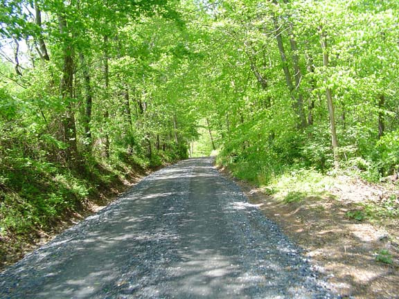
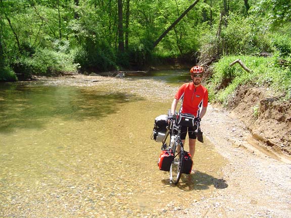
The pavement returned on the other side of the creek, but by now we were used to gravel roads, so when we discovered that another road I'd selected was unpaved, we just took it.

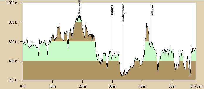
The next town was Urbana, where we took break at the 7-11. After that, we jumped on MD80 which took us down into Buckeystown and the flatlands south of Frederick.

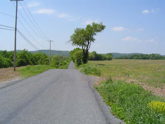
The Flatlands. The Catoctin Ridge looms in the distance.

Our plan was to cross the Catoctin ridge at through a gap near the town of Jefferson, but my map let me down and we couldn't get there from where we were without a lot of extra miles. The only other option was right over the top on Mountville Road. We climbed about 400 feet in about a mile, with a pitch of about 14%. It was unpleasant but we reached the top and screamed down the other side into Jefferson.

After that it was an up and down ride along MD180 until we plunged down to the Potomac at Knoxville, near Brunswick. We rolled onto US340 and climbed for about a mile on the very busy, four-lane divided highway. We made a left onto Keep Tryst Road and then a right on Sandy Hook Road, which dropped us back down to the river and parallel to the railroad tracks and C&O Canal towpath.

We carried our bikes down to the towpath when we came to some stairs and then rode back to the railroad bridge over the Potomac to Harpers Ferry. We humped our (very heavy) bikes up the stairs and across the bridge.


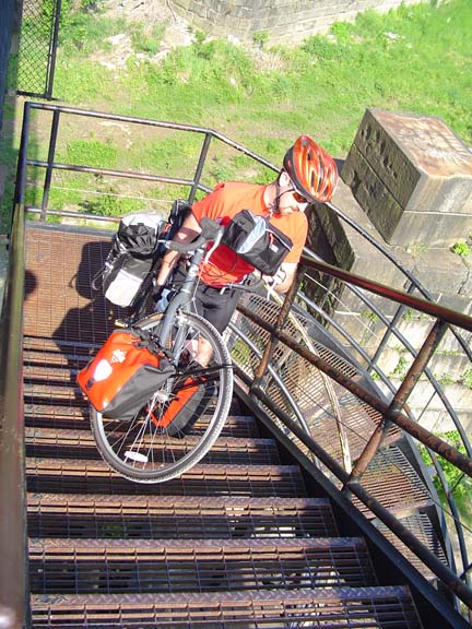
More fun than you can imagine.

A couple of C&O Canal riders followed us up the stairs. I asked them about conditions on the trail. I figured with all our dirt road experience we wouldn't have any trouble riding the towpath on our touring bikes. They said that the trail was pretty dry between Harpers Ferry and Whites Ferry, which was good enough for us.

We ate at a restaurant in town and then climbed up out of town to the KOA on top of the hill. While we were checking in, the girl asked us if we had any pets. I told her we had two oxen.

I don't know about all of them, but this KOA was only a small step down from a motel. It has a gym and volleyball courts and laundry and a gift shop and store. Most of the guests were packed together in a small city of RVs and campers. They were probably closer to their neighbors than they are at home. We were assigned a remote site in the sparsely populated tent section. Of course, there were still plenty of people around but they weren't as tightly packed. We had some trouble finding our site because there was a fallen tree occupying much of it and other campers had made off with our picnic table. There was also no level ground. We expected a little better for $37, so we changed to another site. This one was much nicer and included a Civil War earthwork in our backyard.


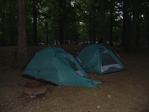
Note the earthwork in back.

It was about 9pm when we turned in for the night. It was cool, very windy, and only moderately noisy but I couldn't sleep. At some point a large branch broke off and crashed to the ground in the unoccupied site next to ours, about 25 feet away. JT slept through it all. I think I finally fell asleep early iin the morning.


Previous | Next

"JT and BC's 2004 Pacific Coast Ride" Copyright © 2004 By Bob Clemons. All rights reserved.